Expedition Himank: A walk in the Girthi & Kio Gaad Valleys
Part 2- The Tethyan Highland
18th June 2011
Day 6- Girthi Confluence(3720M)- Lower Matoli Camping Grounds(6 Kms, 4400M)
 |
| Route on right bank to Glacier snout |
Well before daybreak, Suraj woke me up
“आशु भाई , GPS देना ज़रा ?” said he.
“क्यों , इतनी सुबह GPS क्या करना है ?” – I was trying to muster the courage to actually open my eyes.
“थोडा Glacier तक जा के आना है.” Prof Mal replied.
Suraj has this inexplicable bonding with Glaciers and Glacier snouts; exactly like Arun Negi has his with snow leopards. These are subjects of passion for them and they would go to any length to pursue these passions even in the toughest terrain, weather or physical condition.
“आप लोग trek शुरू करने से पहले ही मैं आ जाऊँगा, 08:30 तक.” He added and set off for the snout of the Girthi Glacier.
 |
| The Kholi complex from Girthi camp |
When all of us finally woke up to a glorious morning, Suraj was long gone with another porter towards the direction where a tall fluted ridge of the Kholi was visible to the left. With tufts of baby clouds variously dotted all over, it looked majestic in the golden sun.
By 0830, when we were getting ready to leave for the day, Suraj walked in as promised. It turned out that he could only manage to go till about 2 Kms upstream and the glacier snout was still as many kilometers away. Essentially, the early morning “snout” exploration had added an additional 4 Kms to his trek for the day. But such are matters of passion J
 |
| Resting at Girthi Top The Girthi ruins visible on left frame |
The frustrating roller coaster ride of the trail was now over. It rose sharply for some 250 meters to reach Girthi Top- well marked by a large Cairn and a pennant. Climbing a further 50 meters we reached a large meadow, through which lay the gently rising trail.
The snowcapped mountains defining the Topidunga area were shining far ahead. It was ‘Showtime!” in the Himalayas J. The Mountain had turned its charm on. The challenges were over for a while; it was time to enjoy the beauty! For kilometers, a green carpet laid spread out with little dots of monsoon blossoms; of yellow, white and orange hues.
 |
| Floral meadow of Khaanagaar |
“जगह का नाम है 'खानागार' साब... बकरिवाले आते हैं यहाँ पर.” Bhuwan informed. “पहले पानी होता था यहाँ, लेकिन आज कल सूखा पड़ा है..”
That’s when we realized that we were thirsty and were running short on our water supplies. The issue was more pronounced for the porters who usually do not carry the sophisticated water-sacks like we do.
To our relief, after five hours of trek since Girthi, we found finally, a gurgling stream of water. Ahead lay a beautiful meadow with a dead glacier adorning one of its extremities. We had reached the midpoint between Girthi and Topidunga- The Malla Kanda Camping ground.
 |
| Droppings containing hair and bones |
Walking into the meadow, we came across some animal droppings that looked like that of some predator..probably feline.
"बघीरा का होगा सर.." said Jaisingh after some careful contemplation. The droppings had components such as hair and crushed bones which indicated it belonged to the carnivora.
The area looked well used by shepherds with more than one shelters visible in that vast meadow. The grassy flat well watered by a maze of streams flowing through.
 |
| Bharat rests under the "Stupa" Rock |
Almost at the entry point stood a strange large hemispherical rock with a verdant green all around. It was almost as if someone had just lifted the finely sculpted rock from somewhere and placed it there. We christened it ‘The Stupa rock”, due to its resemblance to a Buddhist Stupa.
It was too early to camp, yet we weren’t sure of availability of a campsite ahead. Even old Bhuwan was of not much help.
“येहिं तक आया हूँ मैं साब..पहले..फिर Topidunga से आगे का रास्ता पता है.. बस बीच का दो-चार किलोमीटर देखा नहीं है ..”- He admitted. Apparently he had come with his flocks till this point and after a gap of few kilometers, he knew the path from Topidunga onwards.
 |
| The Malla Kanda Camping Ground |
Janak went ahead and before long was seen exploring a high altitude meadow about a kilometer ahead. In half an hour his voice crackled over the radio
“Campsite है सर यहाँ , पानी भी अच्छा है”.
Referring to the GPS map, one could guess this potential campsite to be slightly short of – what’s indicated as “Matoli CG”. After a short climb we reached a meadow across a fast flowing river, very close to a Glacier that was almost invisible with settling clouds. We were at the highest point yet- at 4400 Meters.
 |
| The Lower Matoli Camping Ground |
The wide meadow on the banks of the stream was dotted with Juniper bushes, orange blossoms and little nests of “Phia”.
Jaisingh was excited at the possibility of capturing a live “Phia”. It’s a marmot (arctomys bobac, R Strachey- Geographical Journal, Jan-June 1900, page 166) who calls out in a way that sounds similar to the ascribed name –
“-Phia-phia-phia”-Jaisingh was imitating.
The burrows look like that of rats– but little more sophisticated architecturally, with a small portico and a resting perch. The mountain folks consider the marmot a precious commodity because its body fat is supposed to have medicinal properties that can cure chronic arthritis and rheumatism!
 |
| Burrow of the 'Phia' |
After much fighting with the Juniper bushes, we could gather enough of those leaves and twigs to start a fragrant campfire. At heights above 4000 mtrs where larger plants cease to exist, the Juniper is nature’s gift for creating a fire because of the rich resins contained in its green leaves. The added advantage is the fragrant smoke it creates; one reason why they are extensively used as incense in Buddhist Monasteries.
We had finished setting up the camp when the winds rose and the campsite was engulfed in a cloudy whiteout followed by a light drizzle. The rains continued throughout the night causing much anxiety in our minds. We desperately wanted the weather gods to be on our side. We were about to enter the snow kingdom, which lay beyond the tall ridge to the east of our camp.
***********************************************
19th June 2011
Day 7- Lower Matoli Camping Grounds(4400M) - Topidunga(5Km, 4500M)
 |
| Picturesque - Lower Matoli CG |
A short yet sharp climb brought us to the ridge top, about a hundred meters away from the camp. The wide valleys beyond, led all the way to the snowy ridges of Topidunga.
Close to Topidunga, one could see the course of Girthi East meandering in with a giant curve. The Girthi East is also called the Bhilmagror Nala – named after the Glacier from where it receives her waters.
Close to Topidunga, one could see the course of Girthi East meandering in with a giant curve. The Girthi East is also called the Bhilmagror Nala – named after the Glacier from where it receives her waters.
 |
| The Matoli meadows enroute Topidunga |
“12 बजे तक Topidunga नाला ज़रूर पार कर लीजियेगा . शाम को पानी बहुत बढ़ जाता है ”- Havaldar Kamlesh had told us at the Josimath ITBP headquarters.
The walk till the river was through a beautiful meadow, which is indicated as Matoli Camping Ground in the maps. The Rambha kot ridge (Also called Yango Dhar) on the far bank had begun changing its character. The layered rock bands had given way to fine amorphous dusty deposits bearing a multiple variations of Yellow, brown, grey and purple.
 |
| The Bhilmagror Nala Also called the "Girthi East" |
The river crossing was uneventful. We did not have to use rope anchors, probably because our timing was right. The river had yet to see the afternoon floodwaters.
After a short scramble of about a hundred feet up the left bank of the river we approached the ITBP post which was almost entirely locked except for the fuel depot and one large bunker with a capacity of about 20 beds. The fuel depot was secured just with a thin metallic wire. All other FRP huts were securely locked and sealed. They would remain like that till the post was formally opened.
 |
| The 'Topi' at Topidunga |
The post is nicely done up with channels dug for storm waters, a compost pit, a temple nearby and a flag post in the middle which could be bearing the Tricolor when the post is opened for the season.
About a hundred meters ahead of the post was a large rock in the midst of a large meadow. It did resemble the shape of a large headcover- hemispherical in shape. Legend has it that, the place is named Topidunga after this rock! Topi- Headcover and Dung- Rock.
 |
| Sunset @ Topidunga |
The beauty of the vista was amplified by the changing colors of the setting sun upon mountains that were playing hide and seek with fluffy clouds all over them. The skies were still dense with clouds even as we were inching closer to the realms of high snows.
 |
| Inside the FRP Bunker- party time! |
Bharat’s ipod and Shahid’s portable speakers were brought to good use and the team went dancing for the next couple of hours. Shahid was in his patient role of being the DJ, taking down requests to play numbers from various regional languages. The party ended with a dance performance of the Nepali porters, to the tune of some original Nepali music.
*******************************************
20th June 2011
Day 8- Topidunga( 4500M)- Untadhura Base(5.5 Km, 4900M)
 |
| Easy route to Gangpaani area By the left bank of "Lanka Gad" |
It’s an easy mule track to Gangpaani from Topidunga. The 400 meters rise in altitude is quite gradual and does not take more than 2 hours to cover the 5 Kms distance. All along the “Lanka” (Atkinson, HZ- Vol iii) stream flows by, many a times unseen from the trail. We had decided to leave Bhuwan Singh, Laxman- the Lapthal expert and Joshi- the old porter behind at Topidunga post. They would do a reconnoitering of the route to Khingar La. I wanted to be certain that the exit route posed no problems. Laxman would go on the recee and radio the message about the route condition from top which we should easily receive at Gangpaani.
At 4800 Meters, Gangpaani has historical importance as a campsite. On the route from Lapthal to Milam, this has been a much-used campsite acting as a springboard for crossing the Untadhura Pass. Almost in all accounts written by the English Sahibs, over a period of 150 years prior to independence, there has been frequent mention of this prominent route.
 |
| Sherring/Longstaff expedition(1905) |
A point of note about the name “Shibchilam”- I am inclined to think it might have had some connection with Lord Shiva and Marijuana- the idea came after reading Amish Tripathi’s “Immortals of Meluha”J. Tripathi theorises, rather adroitly, Shiva to be originating from a tribe in Tibet J
Remembering all that one had read, one couldn’t but feel the romance with history. These very grounds would have seen travellers of myriad countries for over a millennium. We proceeded ahead over the mud flats beyond Gangpaani towards Untadhura ridge. That way, we would gain a bit more altitude and would have a clearer view of the Untadhura-Jaintidhura junction.
 |
| Campsite- Untadhura base- 4900M |
The terrain beyond Gangpaani is almost a plain for about two kilometers. The riverbed is as wide as 300 odd meters with hundreds of criss-crossing rivulets upon it. The soil was soft and black as slate. Walking on it, often one had a quick-sandish feeling, as if one is going to sink in any moment. The constant drizzle from above did not help the matters much.
We camped at the approximate place where the route coming from Untadhura bifurcates; one going down to Topidunga and the other traversing up to Jaintidhura. In the golden days of yore, when the Milam-Chitchun Tibet route was at its flourishing best, one Mr Nain Singh Rawat used to have a Tea-stall here, servicing all the traders and yak herders on their way to and from Tibet. All the trade stopped after the 1962 Chinese aggression. The trade route, and the passes have long since been in disuse. Nain Singh’s tea stall has vanished long since.
Of the two passes, we wished to explore Jaintidhura the next day.
 |
| Untadhura ridge from a Kilometer away |
Of the two passes, we wished to explore Jaintidhura the next day.
Jaintidhura Pass is mentioned in all accounts covering the Tibet –Milam route. Yet it somehow has lesser glory and focus, than its less taller neighbor- the Untadhura Pass.
At such places of beauty and history one just gets lost in another timescale..
It’s easy to find the route to Untadhura because its still in use by the ITBP patrol teams and is maintained regularly by the PWD. But Jaintidhura is almost forgotten and so is its route! Signs if any, have been long since obliterated by actions of weather, landslides, avalanches and snowmelt.
 |
| Exploring till the base of Pk 5800 Western sentinel of the Untadhura |
The drizzle stopped by 1500 Hrs almost about the time we recieved the radio message from Laxman:
"हम 52 Bend क्रोस कर गए हैं सर....रास्ता साफ़ है. कहीं कहीं पर Landslide है... लेकिन कोई problem नहीं होगा."
"आप लोग पूरा टॉप में पहुँच गए?" I asked.
"यहाँ से Top तीन किलोमीटर है. ... लेकिन अब ज्यादा चढ़ाई नहीं है.. आसान रास्ता है" Laxman replied.
That settled my worries about the exit. The ITBP personnel at Joshimath had spoken quite negatively about probable route conditions at '52 Bends'- the final obstacle on our exit route to Lapthal.
Since we had time yet in the afternoon, we decided to use the time reconnoitering the area and have a go at the nearest peak if possible. It was a peak guarding the Western fringe of the Untadhura ridge – was approximately 5800 mtrs in altitude.
 |
| Pk 6120 reveals itself briefly The sentinel guarding the East of Untadhura |
In the evening we exchanged notes with Jaisingh who had gone reconnoitering the possible route to Jaintidhura. He claimed to have found a short route to the top, which is difficult to begin with and easy later on. When we asked if he saw a track upon the spur he climbed, his reply was in negative.
Still unsure about the route to follow, I decided on the most certain route for the next morning’s adventure- following the stream that flows down from Jaintidhura and from its source, cut our way to the Ridge Top.
************************************************
21st June 2011
Day 9- Untadhura Base(4900M)- Jaintidhura(4Km, 5620M)- Topidunga(7 Km, 4500M)
 |
| Untadhura ridge- early morning |
There is a magical quality about the Himalayan Landscape in monsoons.
A clear morning in the monsoons is often much more beautiful than the sunny blue skies and the snow covers of the winter. The greenery, the million dots of color and the wisps of clouds clinging to the crannies of the purple mountains are some of the things that one can never see in any other season.
The dawn of 21st June broke revealing one such lucky occasion.
 |
| Untadhura basecamp @ 0600 Hrs |
At 16000 feet, the greenery was missing. But the magic was woven by the interplay of the blue sky, the golden rays of the sun, the fibrous floating clouds, the gurgling streams and the snowlines around us; such spectacle that makes you go scampering for your camera and get lost in the viewfinder.
We had a long day today- climb the 4 Kms to the top of the Jaintidhura ridge and then proceed to Topidunga straightaway after the descent. The camp staff would start packing and would leave for Topidunga, immediately after we had started for the summit.
 |
| Route to Jaintidhura along "Lanka gad" |
We followed the pre-decided course along the Jaintidhura stream. It was a stream with hardly a trickle of water. The soil all around was sort of dark clay. It’s indeed rare to see soil of such stark color and texture that high up in the mountains. After about two hours of steady climb we reached spot that looked like a smoothly baked “Giant Pot”. The darkish looking mound of hard clay was devoid of any snow. This was the half way mark at about 400 meters above where we had started the climb. The Cairn of the Jaitidhura ridge was visible almost vertically up about 400 meters above.
 |
| Jaintidhura- 5620 Meters |
The angle of ascent steepens considerably here after. At about 5400 Meters one can see beyond the adjoining ridge of Untadhura.
That’s when I also discovered, Jaisingh was correct after all. As narrated by him the previous evening, if one managed to climb atop the rocky spur at whose base our campsite was, one could have a level trail from the top of that spur till Jaintidhura ridge. The path we had followed was a long-winded one.
 |
| View north-east of Jaintidhura Kingri-Bingri: Entry to Tibet visible |
“दादा हम top मैं पहुँच गए हैं... बहुत बड़ा सा snowfield दिखाई दे रहा है आगे..निचे...” – said Arun
Some how this message ingested new energy in all of us that were in different stages of the ascent. Exactly at midnoon, the entire team was at the top. (Pawan and Kalyani decided to stay back at the Clay top due to extreme exhaustion).
The view at the top was spellbinding. The focal point on the kilometer long ridge was an old and tall cairn with a flagpole for a pennant that wasn’t there any longer. During the heydays of trading, there would be a colorful flag beckoning the caravans coming from passes at both sides of the ridge- Kingri Bingri La to the North East and Untadhura to the South West. Beyond Kingri Bingri was the Chitchun area of Tibet and to the South of Untadhura was the Johar valley of Milam. Standing atop Jaintidhura, one could scan a large portion of the Milam-Tibet route.
 |
| The route to Pk 6120 Base |
The photo-shoot with the Tricolor on top of that ridge was another experience worth mentioning.
There is a different sensation that runs through your being when you wave the flag of your nation upon its snowy northern frontiers. We were aware that we were the only Indians carrying our flag in that extremity of our borders. The ITBP Post in the area had not opened yet. Words like “Bharatmata ki jai” and “Hindustan Zindabad” came out loud and spontaneous from deep within.
 |
| Tricolor upon the Northern Borders |
A sudden cloud cover came in as if to indicate that the “Show is up!” and it was time to descend. Fortunes can change in a moment when the weather starts acting up at 18300 feet. At such heights, in the afternoons, the weather does act up for certain.
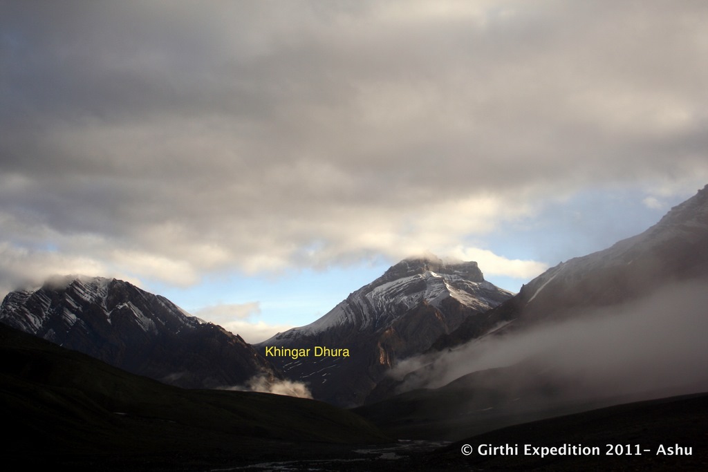 |
| The Khingardhura saddle from Jainti area |
*************************************************
-->
22nd June 2011
Day 10- Topidunga(4500M)- Khingar Dhura(5.5Km, 5280M)- Chudaang CG (7Km, 4450M)
 |
| The Zaskar peaks from Topidunga Kamet(Right), Mana(Center) |
On a cloudless sky, a bevy of peaks in the Zaskar ranges are seen clearly from Topidunga - Kamet, Mana, Nilgiri and Nilkanth to name a few. Such was the morning when we were preparing for 52 bends and the Khingar Dhura.
The anxiety about the route condition was resolved in the mind already; we knew that there wasn’t any insurmountable obstacle. Laxman – the terrain expert from Munsiari had already confirmed that through a recee mission, two days earlier; the trail was ok all the way till the top barring few minor landslides.
 |
| Sumnolti Camping Ground at entry to the gorge |
Following the downward trail from Topidunga one has to cross the “Lanka” stream (coming from Untadhura cwm) to enter the Khingar gorge. There is a bridge across the Lanka, which was currently in a dismantled state. Probably it is assembled back when the ITBP post at Topidunga is opened up in July. Just beside the river is a small meadow called the Sumnolti Camping Ground.
A note on the nomenclature and naming conventions in the area: “Sumnam” in the local dialect is a confluence of two water-bodies.
Here near the camping ground is a confluence of the “Dol” stream coming from Khingar Gorge and the “Lanka” stream coming from Untadhura (Atkinson, Himalayan Gazetteer, 1882, Vol III, pp324).
 |
| Gateway rock- 1905 and Now Only difference seems to be the dislodged rock! |
Similarly, the next big staging point after Lapthal is a place called Sumna. Here the Kio Gad and the Yong Gad come together. The name probably has Tibetian origin. “Tso” is lake and “Chu” is river in Tibetian; indicating a phonetic link with the word “Sumnam”.
 |
| The centuries old snowbridge |
We thought, the 52 bends had started and began counting. Its only later that we realized, the count of 52 starts much later- these 25 bends were bonus!! J
After the ‘Gateway’ rock is a snow-bridge that spans across the “Dol” flowing in icy depths. Both Webber and Sherring have described this snow bridge in their respective books written more than a hundred years back; a permanent natural feature existing on records for more than a century now.
 |
| The 52 Bends |
The trail flattens out onto a gradually ascending slope afterwards. Carcass of long dead pack animals strewn along the way in many places are evidence of frequent usage of the track, possibly by the ration suppliers to the ITBP post at Topidunga.
The terrain, slowly and imperceptibly becomes distinctly trans-himalayan; a remarkable combination of easy angles, brown rocks, tall mountains, large patches of snow and little cloud clusters against the cerulean skies.
 |
| The trudge to Khingar La Untadhura area in the background |
The terrain, slowly and imperceptibly becomes distinctly trans-himalayan; a remarkable combination of easy angles, brown rocks, tall mountains, large patches of snow and little cloud clusters against the cerulean skies.
During this long and frustrating trudge to the top, the team discovered its first fossils. The first of the fossils in this area was collected and recorded by Strachey in 1857, around the time Sepoy Mutiny was going on elsewhere in India. Salter and Blandford analyzed the specimen around 1865 and confirmed their age to be about 6 million years old; the Upper Jurassic age – in geological timescale.
This was perhaps one of the most compelling evidence found about the existence of the Tethyan Sea that existed between the sub-continental India and the Eurasian landmass. It has been recorded that the fossils found here vary in their sizes wildly- from few millimeters to the size of cartwheels with more than a meter of diameter.
 |
| Jurassic fossils hidden in layers of rocks |
This was perhaps one of the most compelling evidence found about the existence of the Tethyan Sea that existed between the sub-continental India and the Eurasian landmass. It has been recorded that the fossils found here vary in their sizes wildly- from few millimeters to the size of cartwheels with more than a meter of diameter.
The ones that we saw strewn along the trailside and hidden between layers of rocks were of comparatively smaller size. Prof Suraj, Negi and slowly the entire team got busy collecting specimens while Shahid, Ritesh and I trudged on till the cairn mark of Khingar La at 5280 Meters. This fossil hunt on the way up actually cost the team an additional hour.
Some of us who reached the pass early, managed to steal an hour long nap while waiting for the rest of the team to catch up. Some spent the time shooting pictures of the Lapthal skyline and the nearby landscape. A comparison with Sherring/Longstaff pics of 1905 shows remarkable similarity of the landscape even after all those years.
 |
| Fossil offerings at Khingar La Cairn |
Some of us who reached the pass early, managed to steal an hour long nap while waiting for the rest of the team to catch up. Some spent the time shooting pictures of the Lapthal skyline and the nearby landscape. A comparison with Sherring/Longstaff pics of 1905 shows remarkable similarity of the landscape even after all those years.
One can see the Chudaang camping ground right from the Khingar La saddle. Marked by a small hillock and a patch of green, the view rivals an oil painting. The colors and lines of the views in any direction of the Khingar valley had that feeling of sublimity about it; it was almost unreal.
 |
| Way down from Khingar La Tiny human beings circled out |
The other thing about the valley was its ability to put things into perspective. The enclosed bowl of the valley floor with its gentle slopes, made it easy to compare things in a single glance. Here, everything human and man-made appeared almost microscopic- the trail looked like a thin thread upon a giant brown plate, the human beings looked like ants and the porters in the distance looked similarly formic.
The descent to Chudaang is easy, along a well-made trail that has been in existence for many centuries. In one or two places there are different versions of the trail visible, indicating that there have been minor course corrections upon this trail over those many decades. The picturesque 7 Km walk form the top finally ends in a meadow which appears maintained by some invisible care-taker.
 |
| Naturally manicured lawns- Chudaang CG |
It’s a large bright green meadow located some meters above a confluence with well-manicured bushes with yellow flowers all over. A rest shed with a small kitchen overlooks the riverside and a FRP hut nearby indicates that ITBP does maintain a post here during season. A stream coming in from the East joins up with the stream coming from the Khingar Pass here. The easterly stream carries the waters from the Kio Dhura and Ghatmila Dhura areas. Those are the other two ancient passes in the region connecting with Tibet.
*************************************************
-->
23rd June 2011
Day 11- Chudaang (Chidamoo)CG(4450M)- Kio Gaad (7Km, 4150M)- Lapthal ITBP Post (4.5Km, 4450M)
 |
| The steep climb to Chudaang Top |
Crossing the river ahead of Chudaang is usually not a problem since that’s the first thing to do while starting the trek early in the day, a time when most mountain rivers have the lowest water level.
The trail rises steeply to Chudaang top at 4600 Meters providing a bird’s eye view of Lapthal valley lying ahead. The landscape is a riot of colors. There are pastures all around, the greens decorated with tiny yellow flowers.
 |
| Greens all around enroute Lapthal |
The route rapidly descends to Kio Gaad river over the next 6 Kms to bottom out at 4100 Meters. A careful scanning of the trailside during this descent can yield few more shapely ammonites for the interested fossil hunter.
We ended up collecting about 20 kgs of the ancient rocks, which were eventually packed and stashed, into the duffel bag causing the hapless porter to comment thus:
“साब यह क्या बात हुई ... अब ration खत्म हो गया तो पत्थर से बैग भर रहे हैं ” – and all of us burst out laughing.
After reaching the riverbed one has to proceed a hundred meters to the east where the valley narrows down a bit and the river offers a few fording points.
 |
| Chudaang Top- Lapthal valley ahead |
The trail rises sharply over the green slopes beyond Kio Gaad to reach the barren brown mounds that characterize Lapthal. These are vegetation less mounds of pre-historic rocks with a very high concentration of ammonites and fossils of various shapes and sizes. But the “Law of Diminishing Marginal Utility” had caught up with us already and we were more interested in locating the ITBP post now. It was critical because we were running low on our food supplies and were relying heavily upon some supplies from the ITBP to line our stomachs for that evening.
 |
| The waters of Kio Gaad |
But the multitude of those undulating mounds makes it difficult to locate a landmark even 500 meters away. We tried doing the next logical thing and targeted the highest looking point where one could make out a shed by the side of what appeared to be a motorable road. It took us another hour to reach the shed at 4600 meters and discover that it was indeed a bunker with a gun emplacement. A telephone wire connected into it from somewhere. We followed the telephone wire for a few meters and could spot a large colony of FRP huts in a grassy hollow, about a kilometer away. A well-marked Helipad and an array of solar panels, indicated, we were indeed looking at the round-the-year ITBP post of Lapthal. A group of soldiers was already gathering there at the courtyard and someone was already examining us with a Binocular.
 |
| To the right of these rocks is the route to Sangcha Malla and Belcha dhura |
An hour later we were seated like distinguished guests in the very courtyard and treated to rounds of packed fruit juices, fresh from the stores of the post. Special sleeping quarters were provided for the ladies in the communications room. The rest of the team was allotted the “Recreation Hall” with a TV that had a TATASKY connection.
In no time each member of our Pan-Indian team had found some jawan from his own part of the country. While Suraj and I got busy debriefing the commanding officer of the post, the rest of the team got busy playing a heady match of “Volleyball” with the jawans. By the time we came out to see the game with the Asst Commandant in-charge of the post, we saw our team members lustily cheering each other in closely fought match in the volley ball field.
The result of our debriefing was evident by evening when a group of jawans came complaining to us
“साब आप का तो trek हो गया, लेकिन हमारे पर मुसीबत आ गयी .” A jawan said with a friendly smile.
“क्यों ?”- I asked
“कल सुबह 6 बजे SRP जा रही है Topidunga के लिए . Asst Commandant साब का आर्डर है. आप के लिए तो adventure है. हमारे लिए तो ड्यूटी है साब... करना पड़ेगा ”.
After we reported to the officer about the fact that “52 bends” was indeed snow free and we crossed the entire route without any requirement of technical aid, he had ordered a “Short Range Patrol” to reconnoiter the trail till Topidunga and asses the possibility of opening the post ASAP.
 |
| The roller coaster route to Lapthal Area where lights were seen is indicated |
In the evening we saw an interesting incident. It was twilight and we were discussing something in the courtyard when someone pointed out to a bright flicker, as if some very bright light was there somewhere beyond the hillocks ahead. One could not see the light source but the darkness did lit up for a while. We thought it must be some sentry flashing his torch onto the hill sides.
Later in the night, a jawan reported the same incident and the entire post congregated in the courtyard. When we asked, what could the reason be for the lights, we got no conclusive answers, as if the ITBP guys avoided answering the question. There were various explanations given- none of which made sense..
“वोहीं पर Chinese ने 120 लोगों का गला काट दिया था 1962 में ”
“शायद lightening है”
“कभी कभी ऐसा हो जाता है, साल में 2 /4 बार . पता नहीं क्यों ”
“Chinese साइड से किसीने लाइट मारा होगा ”..
Obviously there was a phenomena and it had no explanation. A scientific mind might however zero in on possibilities of either a local electric discharge or a light flash from across the border.
Any which way, it did cause some consternation in our tired minds. The warmth of the FRP bunker was welcome. This was the third day after Gangpaani when we did not have to pitch tents.
***************************************************
24th June 2011
Day 12- Lapthal(4450M)- Sumna(14Km, 3500)- 21 Pt(6Km, 3400M) - Malari(21Km, 3450M)
 |
| The 20 Km trek from Lapthal to 21Pt (3 Kms was saved by the ITBP Gypsy) |
A couple of Kilometers after hitting the trail we saw the Kio Gaad valley laid ahead of us and the route descending rapidly down. Within an hour after the jeep ride, we were at Ruli Bagad. I remembered Bhuwan Singh mentioning this place as the terminus of the trail coming over Lapthal bridge in Girthi Valley.
At Ruli Bagad, the trail crosses over to the left bank and follows the river closely for about 4 Kilometers where a bridge brings it back to the right bank. Sumna is on the right bank of Kio Gaad.
A kilometer before reaching Sumna we saw three youngmen waiting by the roadside with a large cask of tea and refreshment along with it.
“आप expedition पार्टी से हैं ?” – one of them asked
“हाँ ”
“यह चाय पानी भेजा गया है आप के लिए . थोडा आराम कर लीजिये !” said the jawan and we were surprised beyond our wits! The post commander had wired ahead of us to provide some mid-route refreshments. There was more in store when we were treated to tasty Pakoras and Nimbu Paani at Sumna. Some of our porters found their village folks amongst the ranks and enjoyed some Fauji lunch.
 |
| The 18Km drive in ITBP truck |
The surprise was complete, when we asked the waiting truck at 21pt, two hours later, if we could hitch a ride till Malari.
“यह ट्रक expedition पार्टी के लिए भेजा गया है”- said the truck driver
When we explained, we were the expedition party, he said “आप ही के लिए भेजा गया है. चढिये और आराम कीजिये ”!!
Asst Commandant Santosh Kumar, the commander of the Lapthal post had indeed taken care to lend a helping hand in more ways than one.
Our hearts went out to the hospitality we received from that band of 70 men living in most treacherous terrains doing their duty of securing our frontiers. The joy one saw in their eyes of seeing people from their homelands can never be described in words. One feels it when one sees it.
We met the young officer from Army Engineers at 21 point where the road construction was going on.
“Ah, so here we meet again!” I exclaimed, seeing him.
The officer beamed his bright smile and we got chatting for a while, him explaining the nitty-gritties of road construction against such challenges of nature. The last 5 Kms to Sumna from Malari, is actually cut through a vertical face of rock, the river flowing many hundred meters below at her ferocious best.
 |
| Team Himank at Malari ITBP Ground |
The focus of the entire team at Malari was to organize a party with local Chhang and a dinner with fresh chicken. Bhuwan Singh was the gracious host at Malari village, treating us to tasty homemade Chhang in his ancient home. He offered me a bottle of special brew as a memento. I shall remember that evening in the smoky hut and that gesture of the old man forever.
 |
| Quintessential Mountain Man |
“दुबारा से आना साब , Sangchamalla और Barahoti चलेंगे ” – Bhuwan said. I had developed a special liking for this old man.
To me, he was the essence of the entire trip. He represented history and age, of days gone by of glory and triumph. He personified unshakeable faith and respect for one and all. He taught his one-point lessons of goodness through the little stories walking through meadows. He feared his gods and loved his animals. He worked hard and accepted challenges that nature threw with a smile; he did not believe he was old- it did not matter to him. He embodied all that happens to the human character when your existence merges with Mother Nature. That’s a gift so rare in the world that I see today.
****************************************************************
The interested may wish to visit the Photo Album of Expedition Himank HERE
Some excerpts from the Team DVD here
****************************************************************
The interested may wish to visit the Photo Album of Expedition Himank HERE
Some excerpts from the Team DVD here