The Saga of 'Chunsa Khaga'
(This expedition won the IMF Award for "Outstanding Exploratory Civilian Expedition" in 2014)
Casting a distant gaze towards the head of the valley and biting on a piece of 'pakora' he said,
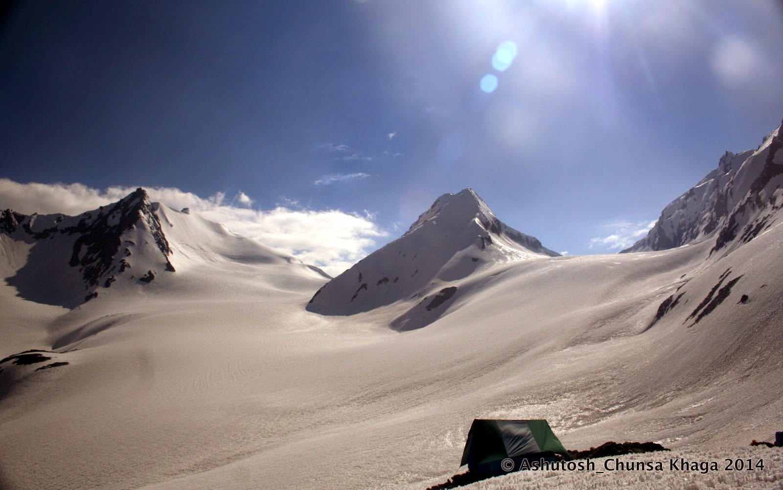 |
| (The Chunsa Khaga- the right saddle @ head of Bushaheri Nala) |
“कैंप है आगे; बुशहरी नाला के पास ”-
he was answering my query about his intended destination.
The youthful spirit and the weather-beaten skin was a perfect
contrast upon Tilak Raj, who had
become our neighbor for the evening, quite by accident. His flock of about 300
sheep was unwilling to cross the engorged stream and the poor chap had been
forced to bivouac for the night near our camp.
We were having an eager conversation with this new neighbor,
huddled around a small fire even as the sun went down over the ridges of the Demoche Dhar- the ridge bounding the western limits of The Chor
Gad valley.
Tilak Raj seemed
to be relishing the freshly fried pakoras as he chatted on.
“क्या नाम बताया ?” I asked
“ बुशहरी नाला ” he repeated “वहीँ रुकेंगे एक महीना अभी। फिर आगे जायेंगे last कैंप तक ” he went on.
 |
| (Tilak Raj from Kangda- Himachal. Has grazing rights of Upper Chor Gad valley) |
The feeling of joy perhaps did not surface on my face. This
was the final validation of our intense research. We seemed to be well on our
way to re-tread on the ancient connect between Bushaher and Nelang; The Chunsa Khaga, a trail and a passage
forgotten for well over two centuries.
The shepherd had just mentioned the local name for the
watercourse along which lay our pre-plotted GPS track. There must be a historical
reason why the shepherds associated that tributary stream in the Chor Gad valley with “Bushaher” – the largest and wealthiest Kingdom in Himachal Pradesh in
the pre-colonial and post-Mughal era.
Our terrain research on Google
Earth had been correct. The double depression on the bounding ridgeline of
that tributary glacier of Chor Gad was
indeed the ancient connect between Bushaher
and the Nelang Valleys!
“हो कहाँ से भाई? गाओं कहाँ पे? ”
“कांगड़ा - हिमाचल” he said nonchalantly as if Kangda was next door
“हिमाचल से यहाँ??!!”
“कई पीढ़ियों से जी आ रहे हैं चराने यहाँ हम तो.. शायद दस पंद्रह पीढ़ी? अब ठीक से कह नहीं सकते।. ”
I made a quick calculation; 15 generations would mean
approximately 300 years!, roughly the time when the Bushaher State had expanded its frontiers and making a
roadmap for prosperity by signing up trade treaties with the neighbouring
kingdoms.
This was the time when the map of the kingdom got redefined, putting the Yamuna valley as well as the western most valley of Janhavi within its jurisdiction and claiming suzerainty over the Nelang Pass (Tsang Chok La) thus securing an additional trade route to Tibet for Kinnauris! The Chunsa Khaga would have fitted perfectly into the scene to facilitate the necessary administrative control.
This was the time when the map of the kingdom got redefined, putting the Yamuna valley as well as the western most valley of Janhavi within its jurisdiction and claiming suzerainty over the Nelang Pass (Tsang Chok La) thus securing an additional trade route to Tibet for Kinnauris! The Chunsa Khaga would have fitted perfectly into the scene to facilitate the necessary administrative control.
Early Mention and Etymology of “Chunsa Khaga”
 |
| (Gerard in 'Account of Koonawar'-1815) |
“Chunsa Khago” –
wrote Alexander Gerard in his famous
narrative on Kinnaur during his visit
there as early as 1820.
In a two-page description, his narrative captured the oral
history and legend around the pass. He mentioned about the armed tax collectors
of the Kingdom of Bushaher going to Nelang area over the pass. He went on then to describe how the pass
had been in disuse after one such caravan, three decades earlier, led by the
younger brother of the Wazeer-Teekumdas[i],
met with an accident and lost few lives.
The name “Chunsa Khago”
appeared to be a tongue twister and did not strike me again till I read up a
book by Fredrick Wilson, the British-born agent of Tehri State for Harsil area, who emerged in the scene about couple of decades later.
 |
| (Wilson in his book -"Summer Ramble.."-1860) |
“Changso Khaga”[ii]
wrote Wilson, “..the pass that
connects Nelang and Bushaher.” Wilson has gone on to explain the meaning of “Khaga[iii]”
without directly contradicting Gerard. In a recent biographical sketch of Wilson, it is mentioned that he may have
been the earliest European to
frequent Nelang and perhaps the first
ever to cross the “Chunsa Khaga”,
apparently also called “Gundar Pass”[iv].
Around the same time that Wilson published his book, the Schlagintweit
brothers from Bavaria published
their extraordinarily detailed research of Central
Himalaya and Tibet. These were based
on their extensive explorations in the 1855-1858 periods. The Chunsa Khaga route[v] is
described in fair amount of detail in it.
Incidentally all of the first few European travellers to the
source of Ganges, including Fraser[vi],
Hodgson & Herbert[vii],
have reported as far back as 1815-1820 that the alternate name of Nielung (sic) village, where the Jadh
Bhotias lived, was “Chunsa”, “Chungsa” or “Chounsah”.
 |
| (Account of Chunsa Khaga route by Schlagintweit brothers in 1860) |
‘Khaga’, as Wilson describes and as is understood by
the people of Kinnaur, Rawain and Taknore even
today, is a high pass of permanent snow (as opposed to ‘Kanda’/ ‘Kanta’ or ‘Khal’ which
is a lower pass).
Thus lexically ‘Chunsa
Khaga’ makes sense. It would then mean, quite logically, ‘the high pass to Nelang’. If that be true, then the name Chunsa Khago as mentioned by Gerard may have been a minor error
either on part of the author or the publisher.
(Gerard’s book was
published about a couple of years after his demise, based on his notes and
diaries, edited and published by George
Lloyd, the son of his co-explorer William
Lloyd. There was little that could have been done, if at all there was an
error in the manuscript or the publication.
British travel
writers of the early 1900s have also regularly pointed out typographical errors
in maps and written accounts, particularly relating to local place names, in
the documentations of the previous century. The British were in a hurry to map the empire, minor typos did not
matter much till someone scrutinized the area further. The detailed maps one sees today are the
products of many feedback and corrections by those early travellers.)
The Rise and Fall of ‘Chunsa Khaga’:
One can only conjecture as to who discovered [viii]Chunsa Khaga and when it actually came
to use. Given terrain-descriptions and the xenophobia of the early Jadhs and their Tibetan Dzong Pens,
its usage by Bushaheris could only
have been mandated by reasons driven by political economy!
Rise of the Bushaher State and Chunsa Khaga
If one scans through the written political history of the
area, which incidentally spans over a 500-year timeline, it becomes apparent
that the modern state of Bushaher was
at the zenith of its power around the mid seventeenth century during the reign
of the illustrious Kehri Singh (Reign 1639-96).
After his demise, the political fortunes of Bushaher
steadily declined till it tapered off around 1914.
 |
| (Tibetan Mural commemorating the Bushaher-Guge treaty) |
Kehri Singh was a
powerful ruler who had not only subjugated most of his neighboring
principalities[ix]
including the Yamuna valley[x] of
Garhwal but also had entered into a
profitable treaty with the with the 5th
Dalai Lama- Losang Gyatso[xi]
of Tibet. The treaty was a strategic
move by both the parties during the “Tibet-Ladakh-Mongol”
conflict of late 1600s. The famous “Lavi Fair” is held till date at Rampur to commemorate that historic
treaty wherein the traders of Kinnaur were allowed to do free-trade in the whole of Tibet "..till there is ice on the Mount Kailash..." The treaty was very much in force till 1962.
The Moravian missionary
and explorer, August Hermann Francke,
found the replicas[xii]
of this treaty in the Bushaher Palace
and Namgia village during his visit
to Bushaher in 1909. To cement the
friendship with Tibet, Kehri Singh married the princess of the Guge[xiii]
Kingdom across the border. The King’s singular focus in advancing Bushaher’s commercial interests is
evident in all written documentation of that period.
 |
| ( Francke discovered the replica of the Treaty at Namgia Village) |
So successful was his reign that many legends and folklores
got woven around Kehri Singh. Such
legends as, the length of his hands reached his knees[xiv]
and that a mini cloud[xv]
hovered over his head when he went meeting Aurangzeb!
Bushaher peaked in its power and
influence during his reign, which ended around 1680.
It is quite likely that during these years of expansion and
consolidation of the state’s boundaries, the Bushaher- Nelang connect would have been established. Kehri Singh’s focus on trade and
economic prosperity hints at expansion of Bushaher’s
commercial interests to the Nelang
boundaries. In fact the maps of Bushaher
have had little change since Kehri Singh’s times, except for separation of Rawain after Gurkha War and have always shown Nelang Pass (Tsang Chok La) as
one of their access points to Tibet through the Chor Gad valley.
Securing this was only practically possible by an internal access across the Baspa Glacier, which could allow the necessary military force required to establish administrative control. The Chunsa Khaga had to be in use if there were to be trading activity across Nelang Pass.
One can verify the above by comparing the old 1911-Map of the state with a modern-day map .
 |
| (Map of Bushaher 1911 - in Kehri Singh's time Rawain area to the south was also part of Bushaher) |
Securing this was only practically possible by an internal access across the Baspa Glacier, which could allow the necessary military force required to establish administrative control. The Chunsa Khaga had to be in use if there were to be trading activity across Nelang Pass.
One can verify the above by comparing the old 1911-Map of the state with a modern-day map .
The above facts only strengthen the supposition that the Chunsa Khaga would have been the busiest
in those heydays of 1680 till almost about the next hundred years, till the Gurkhas invaded the Indian hills including the Nelang tract. Nelang was destroyed by The Gurkhas during their attack in 1804.
History records the possible reasons of the gradual
decrease of transaction and eventual disuse of this pass, which epitomized the Bushaher-Nelang connect. The terrain difficulties did not impact its
fate so much as the political developments did.
 |
| (Modern Map of Kinnaur - erstwhile Bushaher) |
It seems that after the establishment of British superiority
in the hills after the Gurkha war, the political fortunes of the area altered
dramatically. The British, the State of Tehri and Fredrick Wilson of Harsil played a great
part in strengthening Tehri/British influence on the entire Gangetic watershed (including Nelang)and the eventual
waning of the influence of Bushaher.
As evident from subsequent narratives, the influence of Tehri State, backed by the British imperial power, steadily
increased in Nelang during the course
of the 1800s. This coincided precisely with a period of rapid political decline
in the Kingdom of Bushaher. Though Gerard writes about the tax collection
of the Bushaher King from Nelang in 1820, he also mentions that
the last remembered tax collection raid by the Bushaheris was sometime in 1790s only.
By the middle of the 18th century Kehri Singh’s grandson Udai Singh had squandered away much of the power
and fortunes of the once powerful kingdom. The last remaining vestiges of the
erstwhile power was shattered during the ascension of Udai Singh’s grandson Ugar
Singh when the Nepalis invaded[xvi]
the mountain kingdoms around 1803.

Shortly thereafter the Gurkha
war followed and after the Anglo-
Nepalese treaty of Sagauli (1815) the British Government reinstated the young Mahender Singh as the ruler of the Bushaher. But his uncontrolled spending
spree, lax governance and loose revenue management made the state
almost bankrupt by 1850. The next line of successors did not survive even
another fifty years [xvii]and
power changed many hands around the end of 19th century. Eventually
on 4th August 1914, the governance of the state lapsed into the British Crown[xviii].
Strengthening of the Tehri connection, Decline of Chunsa Khaga (Bushaher-Nelang Connect)
 |
| (Raja Sudershan Shah of Tehri- Reign 1815- 1860) |
It is interesting to note, when the young and weak Mahender Singh was taking over administration in the post Gurkha-war scenario, British explorers like Gerard and Hodgson came visiting to Kinnaur and Garhwal respectively. They and subsequent travellers would have only experienced the declining commerce in Bushaher and the rising influence of Tehri where a young Sudershan Shah had now been installed as ruler who was closely watched by the British from nearby Mussorie.
 |
| (Caricature image- Fredrick Wilson of Harsil) |
Fraser in 1815[xix]
and Kinney in 1878 present very
different pictures of the Nelang-Tehri
interaction.
Kinney in his 1878
report mentions about Wilson being
appointed as the agent of the Tehri
Durbar to handle the border affairs in the Nelang area. He writes further that Wilson worked with the Jadhs closely to abolish girl-slavery[xx]
from their society. Wilson’s engineering
adventures in the area, including his initiative in building the 400ft
suspension-toll-bridge over Bhaironghati are
well documented by his biographers.
 |
| (Robert Hutchison, Author of "The Raja of Harsil") |
If one puts the various facts together it would validate the
suggestions made by Hutchison in his
interesting book- The Raja of Harsil. Here he narrates about frequent visits
and transactions of Wilson in the Nelang area. He mentions that Wilson had tremendous hold over the Jadhs and they used to listen to his
counsel.
By 1878, when Kinney from
Survey of India carried out
plane-table work in the area, the Tehri
Durbar already had its customs post[xxi]
at Nelang. He also mentions that by
that time the Jadhs of Nelang had already established a summer
settlement at Dunda[xxii]
near Uttarkashi in the Bhagirathi valley.
Looking at the documented history, it is not difficult to
see that that Chunsa Khaga was an
unaware, innocent and accidental victim of the Great Anglo-Russian Game.
Kinney and Hutchison in their respective writings
indicate that Wilson was in fact
planted by the higher authorities (Col Young of British Intelligence) at Mussorie
to act as an agent (representative) of the Tehri Durbar for the Harsil-Nelang-Gangotri
area. Hutchison suggests with
sufficient rationale that the real purpose of the British was different. It was
to have someone trustworthy to keep an eye out for European and specifically Russian
activity around that part of the frontier.
 |
| (Prince Waldamer of Prussia whom Wilson prevented from Visiting the Nelang Pass) |
How Wilson played
a crucial part in keeping out Prince
Waldamer of Prussia from visiting
the Nelang Pass[xxiii]
is well described by Waldamer’s scribe
Dr Hoffmeister [xxiv]and
well crafted into a narration by Hutchison
in his seminal work on Wilson’s biography.
Wilson seems to
have used his envisaged role, that of governing the trade and taxes of the Jadhs, to gain a close connect with the Jadh community of Nelang and thereby furthering his own and British interests in the back drop of the Great Anglo-Russian Game unfolding in high Tibet.
Access to Nelang gave
Wilson a much wider area of operation
for his business interests in Timber and Game Hunting. In fact Wilson's hunter buddy Col Fred Markham mentions this in 1851 ("Shooting in the Himalayas"-Para 3 pp53);
"..The Neilang Tartars allow Wilson, and anybody accompanying him, to pass into their country..."
The Jadhs were not complaining since their trade interests were protected and now they had added access to secure summer homes in the Bhagirathi valley. The newly established socio-political influence over the Jadhs would have earned Wilson additional brownie points from the Tehri Durbar and his British Handlers!
Bolstering the Garhwali
territorial claim over the Nelang
watershed, he was the first European to
have ever used the term “Jeela Kanta”[xxv]
(the politically correct Garhwali name
of Tsang Chok La- The pass from Nelang to Tibet) in his book frequently to describe the water parting line
that defined the border with Tibet!
The Jadhs started
getting integrated with Garhwal in
more ways than one, both in the socio-cultural as well as in the geographic
context- a process that has continued till date. Even today, their habitat is
the Uttarkashi District (Dunda near
Uttarkashi and Bagori near Harsil) in Bhagirathi
valley and some of them pay an occasional visit to their ancient village
for religious reasons.
However, even today, more Jadhs live in Kinnaur (Janhnavi II, 'The Jadhs of Jadung', Para 4) than in Uttarkashi. In the Joshua Project website, a Christian organisation tracking tribal people, the Jadhs are shown as inhabitants of Bushaher area in the Google Map provided in the page. This clearly indicates the dominant historical connection with Kinnaur, which over a period of time has changed to a deep transaction with Garhwal.
All the above, by design or by default, seems to have
contributed irreversibly towards waning of transactions with Bushaher and the consequent abandonment
of usage of the Chunsa Khaga.
Terrain Research
Coming back to the main narrative, out of the four available
accounts of this ancient pass, at least two centuries old as I write this
today, the following common points emerged.
- The pass was one that connected the valleys of Baspa and Janhavi
- The pass had a connect with the Baspa glacier
- It was close to or above 18000 ft in altitude
- People from Kinnaur and Nelang transacted over this pass to collect or pay taxes to the powerful Kingdom of Bushaher
- Taxation in those days was usually in kind and not in cash
- To carry the tribute or cash loaded Jooboos(crossbred Yak) or pack sheep were in use in those days
- Alternate name of the pass was “Gundar/Gaundar Pass” (thus indicating the necessity that the Gundar pasture had to be on the route)
- After cold and crevasse related accidents the pass fell into disuse
- For 6 days of mule march there would not be a human habitation
- The ascent from Chitkul side is easy and subsequently passes over vast snowfields
- Snow trudge is for about 1 and half days of march which approximates about 15 miles
- The preferred period of crossover is post monsoon meaning the September/October period although there have been mentions of the May-June window also
- From the Chor Gad side the pass is crossed on the third day of march and the long sloping descent on the other side ends near the snout of the Baspa Glacier
- The pass was to the east of the Lamkhaga- Chot Khaga ridge
Tapan Pandit’s
pioneering expedition over the North
Chorgad glacier in 2009 matched several of the above features but not all.
But it was surely a close match in many ways. The route they had forged was a
sure possibility of a regular connection between Chor Gad and Arsomang Valleys.
(Tilak Raj fondly
remembered Tapan Da’s expedition five
years back and mentioned how he met the party near the Thandapani camp, at the entrance to upper Chor Gad valley.)
The few important mismatches were:
- The party jumared up to the pass from Arsomang side. It would have been impossible for loaded caravans to pass through that way
- The Baspa/Gaundar connection was absent
- This pass did not lie to the east of Lam Khaga, neither was it possible to cross in the third march from Nelang; thus contradicting the Schlagintweit route
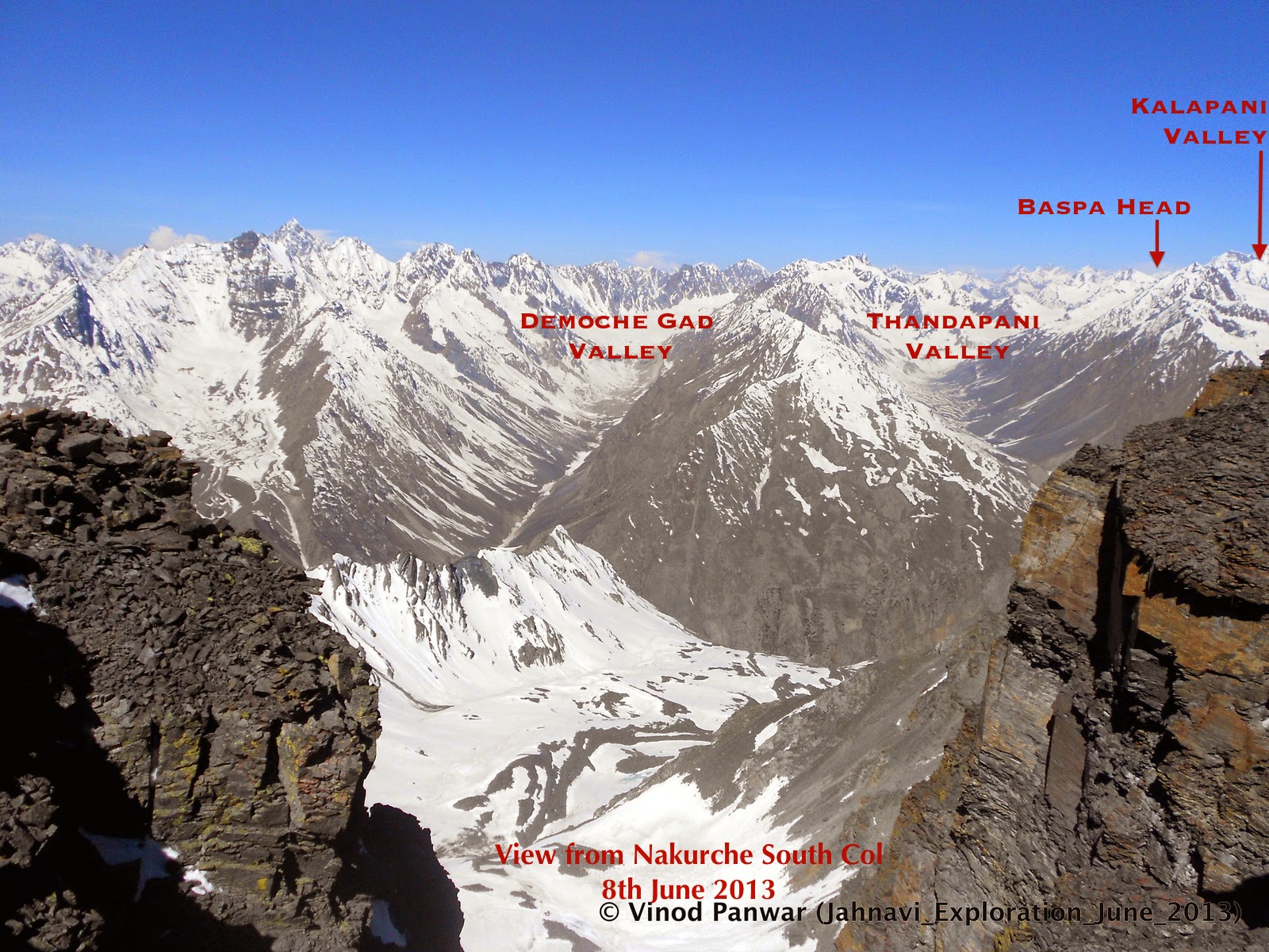 |
| (The pic that led us to the pass) |
It was a chance discovery while verifying on Google Earth, a photograph shot by Vinod from the top of Nakurche South Col during our previous
year’s expedition to Jadung.
I noticed an interesting looking pass to the far right of the picture frame which looked to be pretty much around the head of Baspa. Upon closer examination in Google Earth (thankfully the area is now populated with good high-res imagery) we found every feature of the now-mythical Chunsa Khaga matching! I must have re-checked and compared the elevation gradient of Tapan Da’s route several times! This one looked decidedly friendlier, straightforward and a logical connection between the two valleys!
I noticed an interesting looking pass to the far right of the picture frame which looked to be pretty much around the head of Baspa. Upon closer examination in Google Earth (thankfully the area is now populated with good high-res imagery) we found every feature of the now-mythical Chunsa Khaga matching! I must have re-checked and compared the elevation gradient of Tapan Da’s route several times! This one looked decidedly friendlier, straightforward and a logical connection between the two valleys!
We located it at the little twin-depression at the head of
the Kalapani Glacier- one of the
tributaries valleys in the Upper Chorgad
basin. The depression in the ridge led on into the head of the Main Baspa Glacier.
It appeared to have
an easy angle of ascent and descent, albeit through a crevassed snowfield on
the Baspa side. It looked like the
only chink-in-the-armor along the otherwise impregnable defense of the high
ridge standing between the Chorgad valley
and Baspa Glacier.
 |
| (Sat. Imagery of the target area) |
A little more research and cross-referencing strengthened
our confidence and our terrain research zeroed-in on the specific area.
(While camping later in June of 2014, at the head of Baspa Glacier, we noticed another
depression of similar altitude at the head of the valley south of Kalapani, which was later found to be an
impractical match for Chunsa Khaga features).
Team Planning
The research of satellite imagery and elevation analysis
made us almost sure that we had cracked the Chunsa
Khaga puzzle, at least for now, virtually on our computer screen.
I was happy. Deep in my hearts I am not yet done with the
pretty and mysterious watershed of Nelang, with its myriad enigmas and tales of adventure. This was going to be the
meaningful purpose to the next wander-about in the lovely valley.
 |
| (Elevation Profile of the Chunsa Khaga) |
The contour analysis of the 3D data in Google Earth was encouraging. The saddle of the pass topped out at
about 5500M. The average ascent and descent grades were in the 25-30% range
with peak points not exceeding 60% at only two possible locations. Overall average gradient was 10%; pretty doable, we thought.
The historical imagery on Google Earth fortunately showed us a two-year-old snow-free image of the glacier icesheets, which allowed us to digitally trace crevasses on both Kalapani and Baspa side.
 |
| (Crevasse Analysis on Icesheet- Historical Sat. Imagery) |
The historical imagery on Google Earth fortunately showed us a two-year-old snow-free image of the glacier icesheets, which allowed us to digitally trace crevasses on both Kalapani and Baspa side.
Water bodies were located at convenient places on both sides
of the dividing ridge. Visual
goat-trails could be seen for almost the entire route up the Chor Gad except for the glaciated areas
and the broken Upper-Chorgad banks.
Route design and custom maps for the GPS were complete
within about 10 weeks even as the team was slowly getting formed.
 |
| (The Team- L to R- Arun, Nitin, Venkat, Bharat, Ashu, Sanjit) |
Soon enough an expedition page was created in Facebook and aspirants poured in. After
much requests, additions, apologies and cancellations the final team was that
of 6 people- 5 of us old friends of previous expeditions and a new
addition to the group in the form of the indefatigable Nitin Joshi- a fine addition to the team as we later found out as
he smoothly assumed the twin role of Team
Scout and Stills-expert.
 |
| (The Expedition planning page of the team) |
The Facebook group
served as the virtual meeting ground plus data repository, so that everyone
could be on the same page on the history, route and potential risks etc. The
chosen window for the expedition after much iteration was the 2nd
and 3rd week of June.
We started monitoring the weather and terrain from April 1st
onwards. We were in for some good news! (Though it did not augur too well for
the country’s agriculture). There was a forecast of high probability of El Nino setting in; thus possibly
resulting in a delayed monsoon.
 |
| (Weather update, a week before the expedition) |
As the D-Day approached, the Accuweather forecast, for our expedition window, slowly started
aligning with the El Nino pattern.
Rains were getting delayed and we were seeing more sunny days in the expedition
window.
By the time we left for the expedition, the prediction for
almost a week had been consistently hinting at a sunny sky for almost the entire
duration of the expedition.
The terrain monitoring that we were doing through the EOSDIS
website of NASA was regularly shared on the virtual world of Facebook. We had reasons to be happy in
that department too.
It looked like the existing snow cover was rapidly melting and we were going to have a snow-free run almost all the way till our base camp. We expected snow only on the main bodies of the Kalapani and Baspa Glaciers by the time we started off from Delhi.
 |
| (Terrain Update A week before the expedition) |
It looked like the existing snow cover was rapidly melting and we were going to have a snow-free run almost all the way till our base camp. We expected snow only on the main bodies of the Kalapani and Baspa Glaciers by the time we started off from Delhi.
Confidence grew so much, so that we even looked up the
moon-phase predictions to see the possibility of a moonlit-photo-fest at the
head of the Baspa Glacier.
It is a different thing that later on, when the opportune
time arrived, on a moonlit night of 15th June, all of us were found
snoring in our respective tents after a whole day of tiring snow trudge.
>>>>>>>>>>>>>>>>>>>>>>
Continued in Part II
>>>>>>>>>>>>>>>>>>>>>>
>>>>>>>>>>>>>>>>>>>>>>
Continued in Part II
>>>>>>>>>>>>>>>>>>>>>>
[i] pp 48-49- “Account of Koonawar in the Himalaya”-
Capt. Alexander Gerard, 1815. Gerard mentions in the footnote that he even
managed to talk to few people in the party that went with “Runjeet”. The grandson of the hereditary Wazeer Teekum Das went on to
become the ruler of Bushaher for a short time during the politically turbulent
times there in late 19th century
[ii] pp 150-151- “A
Summer Ramble in the Himalayas”- “Wilson-The Mountaineer” 1860. Under the
pseudonym “Mountaineer”, Wilson describes his deep knowledge of the Nelang
tract and in that mentions the “Changso Khaga” as a straighter but more
difficult alternative to the Lamkhaga/Chhot Khaga passes
[iii] pp 152- “A
Summer Ramble in the Himalayas”- “Wilson-The Mountaineer”, 1860
[iv] pp 58- “Raja of
Harsil”- Robert Hutchison, 2012. In a dramatic reconstruction of Wilson’s
times Hutchison, out of his own research, proposes the Nelang-Chitkul connect
as the “difficult Gundar Pass through Baspa” thus indicating that the
Nelang-Chitkul connect had both “Baspa Glacier” and “Gaundar Grounds” in its
way
[v] pp94- Route#
153- “Results of a scientific mission to India and High Asia- Vol III”-
“Hermann, Adolphe and Robert De Schlagintweit”,1860. The authors describe
the pass as “..At the third march from Nelong cross a difficult pass to the
east of Lam Khaga. The slopes of this pass lead direct to ‘Do Sumdo’ and then
one long march to Chitkul.” The absence of any journal reference in this
documentation is understandable since there have been few written records of
the pass in any previous documents apart from Gerard’s and Wilson’s. This further suggests that Adolphe Schlagintweit would have taken
down the details of the pass from oral accounts during his visit to Southern Tibet.
[vi] pp217- “Asiatic
Researches Vol 13 1822- Account of a Journey to the source of the Jumna and
Bhagirathi rivers” James B Fraser-1815, para 6-“..they stated that they
were inhabitants of the village ‘Chounsah’ consisting of few poor houses..”
[vii] pp91-“Asiatic
Researches Vol 14-1822- A Journal of Survey to the source of the Jumna and
Bhagirathi rivers” Capt. JA Hodgson-10th Regt.NI-1818, para
5-“..’Do Bhasias’ village called ‘Neilang’ in the district of ‘Tungsah’..”
[viii] After the expedition was over, we realized that the
discovery may not have been very difficult since it lies straight at the head
of the Baspa Glacier, which broadly
has a straight-line lay with east-west alignment. One does not even have to turn anywhere
approaching upstream from the Baspa side.
Any curious soul exploring up the gradual plains of the main Baspa Glacier would eventually notice
the pass at the end of his quest.
[ix] pp 107- “The
Princely and Noble Families of the former Indian Empire- Himachal Pradesh, Mark
Brentnall”- Indus Publishing 2004- Para 4
[x] Possibly one of the reasons why we see a distinct Himachali (Kinnauri) influence upon the
people of the Tons valley e.g. Har – Ki- Doon. Polyandry is a distinct Kinnauri trait, which supported their
profession of trading through distant places of Tibet. The Tons valley is the
only place where it is found in practice even today. This politico-economical
influence is very likely to have started at Kehri
Singh’s time
[xi] pp 51- “March
of Central Asia, Ram Rahul”- Indus Publishing-2000, Para 02:“..The
agreement conferred the traders of Bushaher
the right of free trade in Tibet..”
[xii] pp 139- “Loss
of Memory and Continuity of Praxis in Rampur-Bushaher, Contemporary Visions in
Tibetan Studies, Dr Georgios Halkias, Serindia Publications-2009”, para 2
[xiii] pp 173-174-
“Naga Cults and Traditions in Western Himalayas, O C Handa, Indus Publishing-
2004”- The author narrates that the princess was called Guge Rani and
stayed in her separate fortified quarters at Sapani. She was tragically killed
as a result of a conspiracy hatched against her by the Raja’s first wife.
[xiv] pp18-“The
Enchanting Himalayas, Kiranshankar Maitra, Mittal Publications-2002”, Para
6
[xv] pp 6-Part A,
“Bashahr State Gazetteer, Gazetteer of The Simla Hill States 1910”, Para 4
[xvi] pp 107- “The
Princely and Noble Families of the former Indian Empire- Himachal Pradesh, Mark
Brentnall”- Indus Publishing 2004- Para 06: “.. Raja Ugar Singh had the
misfortune to be on the throne at the time of Gorkha invasion..”
[xvii] pp 108- “The
Princely and Noble Families of the former Indian Empire- Himachal Pradesh, Mark
Brentnall”- Indus Publishing 2004- Para 1,2,3
[xviii] pp 109- “The
Princely and Noble Families of the former Indian Empire- Himachal Pradesh, Mark
Brentnall”- Indus Publishing 2004-
Para 02: “..on 4th August 1914 Raja Shamsher Singh died and the
state of Bushaher lapsed into the British Crown…”
[xix] pp217, “Asiatic
Researches- Account of a Journey to the source of the Jumna and Bhagirathi
rivers” James B Fraser-1820, para 5-“..they were poor inhabitants of a
miserable village and had never travelled much..”
[xx] pp- Appendix
-XVIII, ‘Report on Survey of the Western sources of the Ganges- particularly
the Jadh Ganga or Nilang Valley in 1878”, Mr T Kinney. “When the Raja of
Tehri placed Mr F Wilson in charge of his frontier affairs, the Jadhs, their
trade, taxes etc., he abolished the system of slavery prevailing and set all
the slave girls free”
[xxi] pp- Appendix
-XVII, ‘Report on Survey of the Western sources of the Ganges- particularly the
Jadh Ganga or Nilang Valley in 1878”, Mr T Kinney. “The Tehri Raja now has
his frontier customs post at Nelang for the collection of duty from the
traders”
[xxii] -do- “..are deserted during the winter months, the
Jadhs moving down to Bhagirathi and hutting themselves in at a place called
Dhunda about 7 or 8 marches below Nelang”
[xxiii] pp138- “Raja of
Harsil”- Robert Hutchison, 2012. “…but his instructions were to keep Prince
Waldamer and is party away from Nelang Pass”
[xxiv] pp 343-“Travels
in Cylone and Continental India”- Dr W Hoffmeister, 1847. “ Who would have
imagined that our afore-mentioned companion, the English Nimrod, during all
this vexatious and disgraceful business, would be secretly acting a part in the
game, and, while publicly appearing on our side, privately behind our backs,
doing his utmost to oppose our plans”
[xxv] pp 148- “A
Summer Ramble in the Himalayas”- “Wilson-The Mountaineer” 1860. Wilson does
not even bother to mention the Tibetan name of this famous pass- “..this range
is crossed at several places, but the main road leading to the large Tartar
towns of Chaprung and Toling may be considered the actual pass, and is called
the Jeela Kanta..”
No comments:
Post a Comment