(This expedition won the IMF Award for "Outstanding Exploratory Civilian Expedition" in 2014)
The Shepherd Trail in the Smugglers' Valley
Stage 0- The Drive In
Delhi-Uttarkashi (425 Km)- Dumku (108 Km)
We reached Uttarkashi on 7th June by the
appointed time, 12 Noon. The afternoon was spent shopping for local woolens at our
favorite shop near the Uttarkashi bus-stand.
A Jadh family of Dunda owns this shop. Negi
struck up a conversation with the old Jadh
Bhotia, enquiring about the current Jadh
settlements. After coming to know about our past adventures in Nelang and this year’s expedition
objectives he was visibly excited.
“यह prayer flag ले जाइए साब. अगर आपको वो pass मिल गया तो ऐसे जगह पे लगा दीजिये जहाँ इसे हवा लगे ” said the old man brandishing a
sizeable package from under his desk.
“कितने पैसे हुए इसके?” I asked.
“अरे पैसे क्या साब. यह तो हमारा gift है - Jadhon का prayer flag. आप हमारे यहाँ पुराना route ढूंढने जा रहे हो . यह तो अच्छा काम है.”
We later gathered that the handcrafted prayer flag would
have fetched him about a thousand Rupees in a normal transaction, which he so readily
offered us free of cost. His trust on us, that the gift would be well used,
added one more reason for successful completion of the expedition!
 |
| (Discussions at ITBP Matli, Mess Lawns) |
The invite from Commandant
Chandel was a pleasant surprise later that day when we went to pay the
customary visit to the ITBP Headquarters
at Matli.
“Get your entire party in the evening. Lets have a drink
together. We shall meet at the lawns of
the Officer’s mess!” said the commandant putting us instantly at ease,
nipping out any apprehension that we might have had about
dealing with the ITBP personnel.
The evening was spent in a nice chat with the senior
officials of the ITBP Battalion that
looks after the Nelang area. We fondly recounted our experiences with
ITBP during our expedition to Girthi Valley a few years before when Commdnt Chandel was the CO at Joshimath.
“I really like that people like you continue to take
interest in such (inaccessible) parts of the mountain..”- The commandant was
all praises for trained civilians experiencing the extreme mountains.
As the discussion veered round to the route into Nelang and the interesting plank bridge
near Gartang, he was quick to advise
 |
| (The 'Gallery' Bridge the Commandant was talking about) |
“Do not even try walking over that bridge now. It is without
maintenance for many years and the wood planks are badly rotten”- The Dy Commandant then filled us up on their
recent experience of reconnaissance in that area.
“Go meet the Asst
Commandant at Nelang around 1400
Hrs and he should be able to help you with a briefing about the route. You will
have to meet him anyway for showing your papers. That’s the nearest post before
you leave road head”- said the CO.
Few drinks and many plates of snacks later we were a happy
and peppy bunch coming out of the gates of the Matli complex at about 2200Hrs in the night. Tomorrow would be our
first camp on the banks of Chor Gad.
>>>>>>>>>>>>>>
“आप इतने देर कहाँ थे? CO साब ने दो बार phone कर के पूछा. आप को दो बजे आना था कह रह थे.”
 |
| (The Road to 'Nelang' as seen at 'Dumku') |
The post commander at Nelang
was waiting for us at his snow-dome office when we arrived there to show the
papers at 1530.
“थोड़ा देर हो गया Sir रास्ते में. Pagal Nala बढ़ा हुआ था”
We mentioned about the half an hour delay in crossing an engorged nala about 10
Kms before Nelang.
“कोई बात नहीं. चाय लीजिये जब तक मैं आप को route बताता हूँ..” and he started off reeling out route details for the next half an hour.
We absorbed as much detail as we could cross verifying with the terrain map
printouts we were carrying.
After the download of local route intelligence we were much
more confident of the navigation and it looked as if our pre-designed route
plan and time schedule was almost 90% on target. The only thing that could
damage our chances now was the weather and possible terrain challenges during
the decent to the other side of Chunsa
Khaga.
 |
| (Getting ready for the short walk to The Bridge Camp) |
We had dropped the team off at Dumku on our way up to Nelang
so that porter-loads could be made while we were completing the
formalities. By the time we reached back at about 1630, the team was ready for
the short march down to the Metal-bridge over the confluence of Chor Gad and Jadh Ganga.
The Jeeps in which
we had come left back for Uttarkashi immediately
fearing further problems at the Pagal
Nala. We went ahead to pitch the Bridge
camp about a Kilometer away from the road head of Dumku.
The vertical rock faces of granite around the Dumku-bridge camp make for some interesting observations.
 |
| (The Bridge Camp at Chor Gad confluence) |
 |
| (Drift wood camp fire at bridge camp) |
The team seemed to be in fine fettle even as the constant
roar of the two rivers at the confluence reminded us continuously of the raw
power of nature surrounding us. Driftwood was plentiful nearby. Soon we had our
first campfire.
As per our discussions at ITBP-Nelang we had to target at least 12 Kilometers of march the
next day to reach Helipad#3 camping ground (mentioned in the maps as Singhmoche Camping Ground). We started
off lazily around 0800 Hrs even as the sun shined gloriously upon the eastern
bounding ridge of the “Chor Gad” valley:
The Smugglers valley.
>>>>>>>>>>
A Note about the “Chor Gad”
>>>>>>>>>>>
How and when the valley got to bear this notorious name is
still unknown.
Since the days of the early visit of Herbert in 1818, the westernmost valley of the Nelang watershed has always been indicated under this curious
sounding name; Chor Gad. “Chor” in Hindi means a thief and hence the
possible local legends about tax evaders using this valley. Who were the smugglers, what did they smuggle
and which tax did they evade etc. have never ever been documented.
In the melee of Tibetan
sounding names in the same watershed (Nelang/Jadhang/Sumla/
Thag La/Puling Sumdo/Chunganmu/ Tsang Chok La) how the “Chor Gad” carried its distinctive Hindustani flavor is also unknown.
One hypothesis could be- after the Bushaher-Tibet treaty[i] of
1680, the able administration of Kehri
Singh would have exploited trade through Nelang Pass. For securing this interest, they would have had to
assert control over Nelang Pass through the Chor Gad valley.
Perhaps in those times, Bushaher may have played a role in christening of the valley with an overtly Hindustani name unlike others in that watershed.
Perhaps in those times, Bushaher may have played a role in christening of the valley with an overtly Hindustani name unlike others in that watershed.
 |
| (The Schlagintweit brothers, explored Himalayas in 1850s) |
The alternate hypothesis could be built from the
extraordinarily detailed research of the famous Schlagintweit Brothers. Their work was based on the explorations they
carried out in the 1855-1858 period. They clearly mention the name of the
western-most tributary of the Nelang
watershed as, a very Tibetan looking,
Tsor- Gad [ii]-
not Chor-Gad.
It may not be too far fetched to imagine that the former may
have been the original Tibetan name that over a period of time could have
gradually devolved into the later. The Schlagintweits have referred to the
river as Tsor Gad with out any
journal reference, which would mean that the data was collected from direct
oral accounts during their prolonged exploration of the area.
>>>>>
Stage I- Shepherds’ Trail to Bushaheri Nala
Dumku 3300 M- Misosa 3700M (12 Km)- Thandapani 4050M (12 Km)-
Kalapani 4350M (6 Km)
The route snaked its way along the true left of the river
for the initial kilometer or so and then across a metal bridge to the true
right. Another hour of spirited walk took us past the Lal Devta #1 camping ground
and then onto another possible campsite that on our Map was indicated by the
old name of Namti. The ITBP calls
this camping ground Helipad #1. Though
these are good grounds, accessibility of water is an issue.
 |
| (Looking upstream, the bridge before Lal Devta #1) |
“ Dumku से तक़रीबन डेढ़ kilometer baad लाल देवता #1 ayega. अच्छा camp ground है लेकिन पानी का दिक्कत है. उसके थोड़े आगे बकरीवालों का डेरा है पानी के पास, वहां अच्छा पानी मिलेगा.” I remembered the detailed
briefing by Asst Commandant Dimri of
the Nelang post.
“ उसके थोड़े आगे हमारा winter camp-ground है - Helipad #1. वहां पानी मिलेगा main नदी से.”- His information had been detailed and
accurate.
“कोई बात नहीं – आप लोग आराम से Heli #3 तक पहुँच जाओगे पहले दिन. नाले में गन्दा पानी आता है वहां. हमने चस्का बना रखा है साफ़ पानी के लिए एक पत्थर के पास..” the post commander had added.
>>>>>>>>>>>>>>>>
A Note on Lal Devta(s) of the Chor Gad valley
>>>>>>>>>>>>>>>>
 |
| (Lal Devta #1, Chor Gad Valley) |
The practice of Lal
Devta worship is seen frequently, in the valleys that Jadh Bhotias stay in. Both Jadung
and Harsil valleys are fine
examples of these. The typical Lal Devta shrine
is located at a high place involving reasonable toil to reach. Such shrines are
never more than one in number in a single valley and are usually identified by
piles of Bharal Horns, empty bottles,
dry coconuts and similar offerings.
 |
| (Lal Devta #2, Chor Gad Valley) |
None of the Lal Devta shrines
in the Chor Gad valley display these
features. There are no offerings, neither are there the customary Bharal horn, bells and the colorful
prayer flags; the “devta” status is
only justified by the red pennant tied to a flag pole. But then that is
precisely how Survey poles were
indicated in those days – a red pennant on top so that it could be recognized
several miles away through the theodolite to triangulate positions!
It may not be too much to assume that it was perhaps the
surveyors like Herbert, Kinney, Ottley and Auden who might have played an influential role in introducing the concept
of Lal Devta into the Chor Gad valley by way of erecting
impressive survey cairns in various high points.
>>>>>>>>>>>>>>>>
Soon enough we reached a camping ground, indicated on the
map as the Langling Camping Ground,
with signs of step cultivation nearby.
The increasing roar of the river indicated the approaching confluence where
the Chaling Gad from the true right
joins in with the Chor Gad.
The confluence is not visible from the trail but one does enter a boulder field indicating the widening of the river bed just before the confluence. After the boulder field we recovered a faintly visible trail, running along the true right of the Chaling Gad.
 |
| (The boulder field at Chaling Confluence) |
The confluence is not visible from the trail but one does enter a boulder field indicating the widening of the river bed just before the confluence. After the boulder field we recovered a faintly visible trail, running along the true right of the Chaling Gad.
We were eager to locate the log bridge over this stream. During the half a kilometer of anxious
searching, as the path wound up along the right bank of Chaling Gad through dense forests, we presently came across a group
of four shepherds with as many mules heading down towards Dumku.
After a brief download from them on the route features ahead, we soon saw the sturdy log bridge laid across the Chaling Gad.
 |
| (The forest trail where we met the muleteers) |
After a brief download from them on the route features ahead, we soon saw the sturdy log bridge laid across the Chaling Gad.
The bridge is about half a kilometer above its confluence
with the Chor Gad. We found all the
bridges in the valley in fine condition, seemingly undamaged by the unusual
precipitation and disastrous flooding that gripped the whole of Garhwal in the monsoons of 2013
 |
| (the Log Bridge or Sango over Chaling Gad) |
After gaining the opposite bank, a short scramble of about
100 meters brought us onto a table top upon a small densely wooded hillock.
This hillock rules over the Chor Gad -Chaling Gad confluence and perhaps can
be called as the Chaling Hill or Chaling Jungle. The ITBP and Shepherds
however, conveniently called this the Lal Devta hill. No real sign of Lal Devta worship exists here though,
other than the remaining vestiges of, perhaps an old survey cairn and its
ramrod straight 15 ft long flagpole.
 |
| (The short scramble up to Lal Devta #2, Chor Gad valley in foreground) |
The dense pines grove around the Lal Devta rock provided us the much-needed shade for resting as we
waited for the team to regroup. This was the first day and the physical
challenge was apparent on the face of few team members. It took us two hours to
regroup and then we made a huge navigational blunder!
I had sent out Joshi, the senior-most porter and seasoned
fuel carrier of the team to reconnoiter the route ahead of Lal Devta. I had assumed the route to be moving easterly, directly
descending to the Chor Gad below.
“Lal Devta #2 से सीधा उतराई है bridge तक . Bridge के पास भी आप camp लगा सकते हैं ”- The
Nelang post commander had said
earlier.
“ढलान बहुत है साब . रास्ता उधर से होगा”- said Joshi, as I looked towards the northerly
direction being pointed out. A trail was
snaking into the jungle on a level ground.
 |
| (The GPS Plot of blunder that cost us dear, Left=North) |
We committed the blunder about 200 Meters down this trail
where it bifurcates into two– one moving left upstream and the other downstream
towards the right. We chose the former and lost considerable time and distance
trying to locate the bridge across the Chorgad.
After an hour of anxious search and a kilometer of
unnecessary trudge we finally found ourselves on the left bank of Chor Gad. Conveniently around the same
time we found the muleteers we had met in the morning returning back. They
slowly inched ahead of us and were soon away from our visible range within an
hour.
Their trail led our way now on.
 |
| (the gentle yet frustrating slope of Misosa, this walk just never ends!) |
Half an hour after gaining the left bank we entered the
gentle yet frustrating slope of the Misosa
grounds. Within another hour we had crossed over the Misosa stream coming from the glacier fields high above to our
right.
I saw the shepherds’ mule train vanishing over a rising
slope about a kilometer ahead even as we approached the sprawling Misosa camping ground with signs of few
old shepherd encampments nearby. The Misosa
CG is located almost on level ground with the Chor Gad flowing fast less
than a hundred feet away.
The team had again grown a long tail and radio enquiries
revealed that the farthest members were at least an hour behind. It was already
1430 hrs and the sun was on its way down towards the western ridges. I decided
to camp rather than pushing for the additional 2 kilometers to the Singhmoche Camping Ground (Helipad #3 as the
ITBP men called it).
 |
| (The Birch forested Misosa Camping Ground) |
Camp was set up on the right bank of Misosa stream well above the traditional camping ground. The
quality of water on the Misosa stream
was much better compared to the muddy waters of Chorgad that at the campsite below.
Our fully laden porters had already covered 12 Kms on the
first day and the net altitude gain was 600 Mtrs; an impressive feat by all
standards. As for the six of us, our unpracticed limbs were acclimatizing to
the mountain environs rapidly.
Shortly after setting up camp we had an unexpected visitor from
the neighboring campground on the left bank of the Misosa stream. He was a shepherd who had started off from Dumku that morning an hour after we
started and had covered all the ground with his flock of about three hundred
heads of goats and sheep. The poor animals were now afraid to cross the log
bridge over the Misosa stream and the
poor chap was now resigned to bivouac there for the night..
 |
| (Our unexpected visitor- Tilak Raj) |
Dead wood and half burnt logs were plenty in the vicinity.
While the kitchen got active in preparing pakodas
and tea, we setup a nice campfire and invited the shepherd over for a
tete-e-tete. We had enough route intelligence already; we wished to now dig
into the life and history of the men who were regular visitors into the valley.
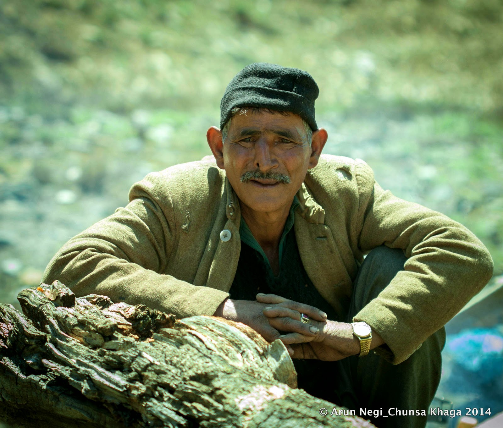
The thirty something shepherd Tilak Raj, with weather-beaten skin and twinkle in his eyes, was
enthusiastic in his narration. At the
end of an hour of chatting up we had gathered the following interesting trivia.
All the shepherds operating in the Chor Gad valley were from one geographical area in the Kangda valley of Himachal. They were two different groups of shepherds
who had well demarcated grazing rights in the upper and lower part of the
valley’s rich pastures. Tilak belonged
to the one with rights of the Upper
Chorgad valleys. Because of the heavy snowfall in the winter, they were
making a late entry hoping that by the time they reach their targeted grounds,
snow conditions would more favorable.
 |
| (Govind Singh of Changdum Plains) |
Another seasoned shepherd called Govind Singh whose muleteers we had met in the morning led the
other group of shepherds. They had moved into the valley already and may be
camping a little distance ahead at the Changdum
plains (called Helipad #2 by the men from
ITBP).
“दो number helipad के पास आप को shepherd मिलेगा गोविन्द. नाक उसका थोड़ा सा टेढ़ा है … भालू ने attack किया था उसको कभी” – the officer at Nelang had briefed us earlier.
When our discussion veered towards the objective our
expedition, Tilak fondly recalled the
Tapan Pandit’s visit in 2009. He narrated
how he had met Tapan Da’s team near Thandapani camp. That’s when he mentioned
that the Nala ahead of Thandapani and Dudhpani was called the Kalapani
camp, which was also called the Bushaheri
Nala by the shepherds.
“बुशहरी नाला क्यों कहते हैं उसे? क्या बुशहर का रास्ता था वहां से?”
“हो सकता है शायद. यह तो बहुत पुरानी बात है, हमारे पुरखों के time का”
“कब से आते हो यहाँ ?”
“ बहुत पीढ़ीओं साब। परदादा के परदादा के टाइम से भी पहले …”
We were a satisfied bunch that evening. Not only because the
story telling around the campfire was romantic but also because our research
seemed to have been in complete alignment with the shepherd legends of the
valley and our navigation plan seemed to be bang on target.
We just needed to
execute our plans swiftly and carefully.
>>>>>>>>>>>>>>>>>>
>>>>>>>>>>>>>>>>>>
 |
| (The Misosa Marine Drive) |
The picturesque trail next day first led us along the
riverside over a kilometer long marine drive. Then it rose sharply for about
200 meters as we emerged upon a boulder field. The field was separated from the
high bank of the river by a grassy ledge about 100 meters wide.
Even as we were trying to locate the route over the
confusing boulder field, Sanjit’s
voice crackled over the radio:
“Ashu come in come in. The ITBP guys have arrived on their
SRP”.
We were happy to see the post commander of Nelang with a small detachment of Jawans, INSAS Rifles slung across their shoulders. We chatted up waiting
for the team to regroup as the ITBP team caught up with us. They had started
that morning from Nelang and were
there near our campsite by 0900 Hrs.
 |
| (Tete-e-tete with the local post Commander) |
Chatting up with the
post-commander I gathered, he has been posted at Nelang for the last three
years and belonged to Dehradun originally.
“बच्चों का पढाई?” I asked
“बड़ा वाला IIT कर रहा है कानपूर से” he said. The father
in me could almost feel the swelling of his chest in pride.
The soldier at the northern frontier had been able to see
his eldest son through the one of the best technical education the country can
provide; Perhaps the best in this part of the world! I was happy for him.
 |
| (Lal Devta#3 and Changdum Plains) |
A little ahead beyond a fast flowing stream was a large rock
with the usual red pennant on a tall flagpole indicating Lal Devta #3. Up ahead the vast Changdum
plains opened up; gigantic fans of glaciers dead many years ago upon which a
luxurious pasture had developed, dotted at this time of the year with pretty
yellow flowers.
Soon we saw a shepherd from a distance whistling merrily.
Coming closer I could see the unique facial description of Govind Singh as I had heard earlier- remnants of his years of
struggle for livelihood through the dangerous terrains of high mountains. Here
was a man who had a hand-to-hand combat with a Himalayan Bear.
 |
| (Our host, shepherd Govind Singh leading us all to his camp) |
He went about his assumed role of the “host” merrily. Soon
tea was served as the ITBP team got busy in pitching their tents and we got
busy in clicking our cameras trying to pose with the gun-toting soldiers.
They were going to camp along with their old friend Govind that night. They intended to come with us till their last patrolling point and after a night's rest at this camp, would go back to their post next day.
They were going to camp along with their old friend Govind that night. They intended to come with us till their last patrolling point and after a night's rest at this camp, would go back to their post next day.
 |
| (Looking back from Misora camping grounds) |
Just about two kilometers ahead of Changdum, where the course of the Chorgad takes a wide sweeping turn towards far left , we went past
the Misora Camping ground sprinkled
with floral dots of yellow and purple. The flowers were getting ready to bloom
and perhaps by the end of June the place had the potential to become a mini Valley-of-Flowers.
 |
| (Exposed scree slope before Demoche Gad) |
A massive scree slope was now looming ever closer at whose
feet the Chor Gad flowed swiftly. The
trail led diagonally over this exposed slope and high above a sizeable herd of Bharals grazed about merrily threatening
our passage with potential rock fall.
The passage went smoothly as we entered level ground now,
heading north again after the westerly diversion on the slope.
 |
| (The Marine Drive of Demoche Gad) |
The trail now ran by the riverside causing another pretty
marine-drive. We were in the Demoche pastures
where the Demoche Gad confluences with the Chor Gad on its true right. The river is
not difficult to cross here and on the far side we could see groves of Birch, many potential camping spots and
an abundance of pastures for grazing.
Lost in that ethereal beauty of the pretty valley, resting
by the riverside we regrouped and had our lunch unaware about the terrain that
was about to hit our trail.
 |
| (The stinger after the Marine Drive) |
After the Demoche Gad
marine drive, at the end of the pleasant walk along the left bank of Chor Gad, the trail suddenly winds
nastily upwards to the crest of a spur coming out of the Nakurche complex, a spur that pushes the bed of the Chor Gad sharply due west.
After a sudden rise of about 50 meters the trail levels out
and enters the wide fan of the moraine of the Nakurche Glacier coming in from the right, from the east. The
snowline of this glacier has receded much farther up; what remained on our
trail was a massive boulder field.
 |
| (Shepherd shelter ahead of boulder field, looking upstream) |
Immediately afterwards one comes across a shepherd shelter
perched on top of a precipice directly looking down at the Chor Gad coursing through about 300 ft below. Just ahead was the
bad patch everyone had referred to earlier.
“मैदान के बाद थोड़ा ख़राब रास्ता है. फिसलन वाली मिटटी है थोड़ा. वैसे हम जा रहे हैं, घोड़ों के लिए रास्ता बना लेंगे.” Tilak Raj had informed us during our
little chat up at Misosa.
“Last का 200 meter लगभग थोड़ा ख़राब है. बस उसके बाद Thandapani आ जाता है snow bridge के बाद. ऐसी कोई बात नहीं है , थोड़ा step
cut कर के और जूता मार के आराम से जाया जा सकता है”- the briefing by our
friends in ITBP had been more reassuring.
 |
| (The 'Kharaab' patch before Thandapani) |
This was decidedly a bad patch of about a furlong and
“kharab” had been a serious understatement. There were myriad rain water
gullies running through a broken bank of loose scree. The Chor Gad, releasing itself from the icy confines of its upper
valleys, was foaming about 250 ft below. Steps had to be cut for the laden
porters and we had a cautious passage except for the minor mishap of Nitin. He lost a footing and was found hanging
on to dear life on all his fours upon that slippery slope. His ordeal was over
a few minutes later when one of our Nepali
porters jumped across to lend a reassuring hand.
 |
| (Thandapani area as seen from the bad-scree patch) |
Soon after the patch of bad scree the trail levels out with
the river and a passage has to be found to the right bank over a crevassed snow
bridge. Since all local navigational instructions had depended on this snow
bridge for crossing over the Chor Gad,
I assumed the bridge to be of a permanent nature. It certainly appeared so,
looking at the amount of deposition of snow and glacial debris.
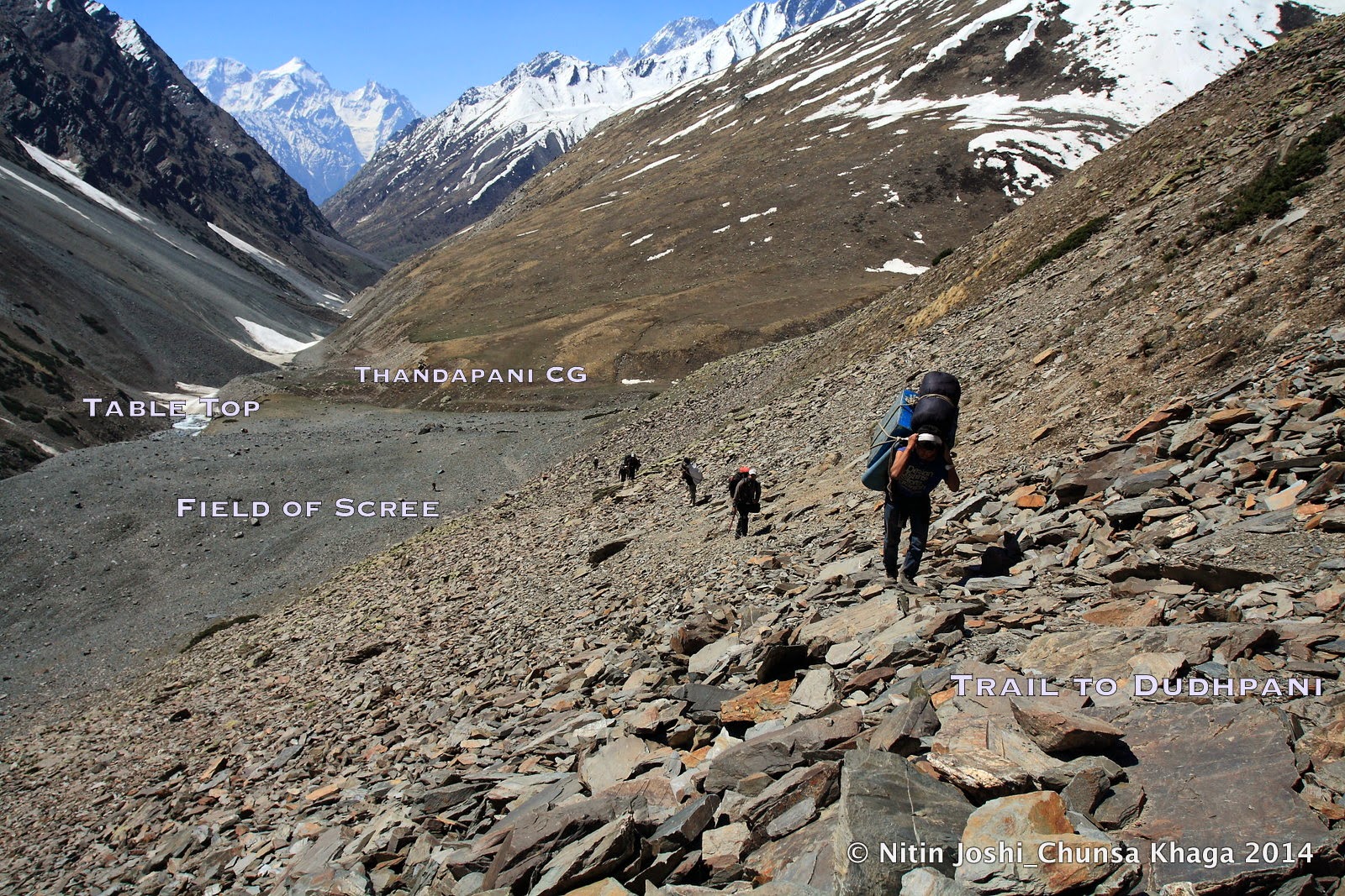
The trail slowly rose up the right bank and with in about
half an hour we were resting on a little flattish delta on the southern edge of
the confluence of a stream coming in from our left. A small stone hut with
ramshackle roofing dominated the scene. Some firewood was littered around. We
had reached Thandapani camp.
 |
| (Thandapani CG, Upper Chorgad view in background) |
I walked up to the edge of the tabletop and had a look at
the confluence. The Thandapani stream
was bringing in a respectable volume of muddy brown water to merge with the
relatively clear body of the Chor Gad.
Over the furious flow of the Thandapani was
a small natural rock bridge, which had been further reinforced by rock masonry,
most probably by the local shepherds, as Tilak
had mentioned.
 |
| (Navigation plan for next day, porters anxiously watching) |
“The chap was right. Tomorrows trail looks to be on this
right bank only!”- We were discussing, even as our anxious eyes started tracing
out the trail rising rapidly up towards the crest of a spur that defines the
southern boundary of the Dudhpani valley
up ahead. Soon Vinod managed to
engineer a little water hole on the sandy shore of the Thandapani stream, which provided bucketsful of clean water for the
entire camp.
The shepherd shelter served as a warm kitchen for the
evening and the bright moon heralded a feast of night photography in the coming
days; we were soon to enter the kingdom of snow.
 |
| (Approaching full moon- seen from Thandapani CG) |
Terrain conditions were exactly as per the imagery in the
EOSDIS website. We had yet not been obstructed by snow and did not expect to be, at least till the next campsite. Weather was still holding good as per
predictions and we were at the gateway of the upper Chor Gad valley covering 24 kilometers in 2 days with altitude gain
of about a thousand meters.
“Not bad!” I mused “if we continue this way we should target
to be over the pass in next 4 days!” – I wished dearly that the weather and
team health held good. Porters looked to be in good spirits without a grumble
about the two consecutive long marches carrying double-loads.
>>>>>>>>>>>>>
 |
| (The trail ahead of Thandapani towards Dudhpani) |
The trail next day dipped down to the bridge over the Thandapani and then sharply rose up
about a hundred feet to land us on another tabletop of rock and scree. The
trail hence wound steadily up for about 200 meters till the crest of the spur
that bisects the right bank of Chor Gad
between Thandapani and Dudhpani valleys, almost plonk in the
middle. We had already crossed the 14000 ft mark and the exertion was telling.
On the far bank we saw the moraine filled slopes dropping in
sheer precipices from a ridge-line about a 1000 meters above us.
 |
| (Approaching Dudhpani valley) |
Soon the trail levelled and dropped down to the lovely valley
of Dudhpani. True to its name the
water was clear as spring water although it clearly was coming from glacial
melts and was passing from under snow beds and ice sheets. But what a contrast
with Thandapani!!
Our intended campsite was in the next valley by the banks of
the Bushaheri Nala at Kalapani! I wondered for a moment if the name
had anything to do with the color of the water source nearby. Didn’t appear to
be too palatable or potable an idea!
We didn’t have time to partake of the beauty of the lovely Dudhpani valley to the fullest. It is a
recommended halt for future travellers into the valley. One just has to push an
additional hour after reaching Thandapani
the previous evening!
 |
| (Sharp ascent ahead of Dudhpani) |
“रास्ता ठीक नहीं है यहाँ से Sir. निचे जाना पड़ेगा नदी से. वैसे camp site दिख रहा है यहाँ से”- called out Vinod, the lead scout, on the radio.
 |
| (Beginning the sharp descent to the river bed - left frame) |
Apparently our current trail headed into a massive landslide
zone to skirt which we would have to climb another 1000 ft higher.
(We realized our mistake later. We should have started our
diagonal climb much higher up in the valley of Dudhpani. That would have
allowed us to gain the crest much above the landslide area.)
The sharp descent to the bed of Chor Gad, the subsequent river crossings over the network of snow
bridges and final climb to the terminal flats of the Kalapani Glacier added at least an hour of delay to the days work.
The snow conditions helped in all the crossings; otherwise it would have been a
nightmare to traverse that patch along the river. Future parties shall be well
advised to take the upper bridle path from Dudhpani
to Kalapani.
 |
| (The Kalapani CG/Nakurche CG) |
Kalapani (As in SoI Map) or Nakurche (US Army
Map-1952) was the most picturesque camping ground we had settled into since
the beginning of the expedition.
A network of streams fed a small glacial lake near the brim
of the basin by the riverside. The dark color of the rocks on the stream-bed was
indeed rendering a blackish hue to the otherwise clean and transparent
water. It looked as if a clear stream of water was flowing through an
undisturbed coalfield camouflaged under various hues of green, brown, yellow,
purple and white.
 |
| (The Kalapani stream near campsite) |
Rajender and I reconnoitred ahead for about a kilometer to verify the ground conditions. From now on we
shall be on uncharted terrains solely dependent on features, landmarks and the
GPS.
Snow conditions did not spring any surprises.
The entire valley of Kalapani
was under a white sheet just about half a kilometer ahead of the camp. Some
hints of brown were visible on the northern walls of the bounding ridges but
not enough to serve our purpose. The long lateral ridges, which were supposed
to lead us to the head of the glacier, were totally snowbound. Brown patches
there would have surely helped our speed and safety. But all in all we were
happy with our assessment.
>>>>>>>>>>>>>>>>>
Continued in Part III
>>>>>>>>>>>>>>>>>
>>>>>>>>>>>>>>>>>
Continued in Part III
>>>>>>>>>>>>>>>>>
[i] pp 139- “Loss
of Memory and Continuity of Praxis in Rampur-Bushaher, Contemporary Visions in
Tibetan Studies, Dr Georgios Halkias, Serindia Publications-2009”
[ii] pp94- Route#
153- “Results of a scientific mission to India and High Asia- Vol III”-
“Hermann, Adolphe and Robert De Schlagintweit”,1860.


Lama&Nunnilangpass.jpg)


Hundes_seen_from_Tsan_Tsok_La1882.jpg)


GangotriValleybetweenBhairoughattiandGangotri,Griesbsach,1883.jpg)
waterfall.jpg)
GroupHunias&Niticoolies,ShirkiaCamp,Hundes,North_of_NitiPass,Griedbach,1882.jpg)


.jpg)


